Made my way down to Albuquerque, New Mexico by way of the Great Basin and then across the Colorado Plateau. I had some time on my hands, and my wife had flown to Las Vegas for one meeting, and then on to Santa Fe by way of Albuquerque for another.
She works on environmental issues, helping to provide citizen input to the cleanup effort from years of nuclear mess-making at places such as the Nevada Test Site, the Los Alamos National Lab, the Idaho National Labs, and the Hanford Nuclear Reservation. That legacy serves as a semi-permanent reminder, given the half-life for of the radionuclides entombed at these sites, of how foolish it is to allow a handful of powerful Senators and Representatives to make all the decisions about labs doing such dangerous and dirty work. There was no public input at the time much of the mayhem was going on in the 1950s and 1960s. It wasn’t till 1972 that the Federal Advisory Committee Act was passed. FACA boards now ride herd over some of the more twisted notions that emerge from the bowels of the nuclear establishment, since the lunacy got seriously out of hand. Chairs of these boards get together once a year to compare notes, rotating between the DOE sites scattered across the country. It was Los Alamos’ turn, and that’s why she was headed to New Mexico.
It was easy to use her trip as an excuse to throw camping gear together, and to head on down the road and collect her, so that we could make our way back home to Oregon.
That’s a 1000+mile trip, so it’s impossible to give you more than a small set of observations. Even now after all these years of living in the West, I’m still stunned at the expanses and the timelessness of the place. There are endless mountain ranges, deserts, prairies, and the towns and cities of course. Here are a few impressions.
The Aeolian World
Night was falling as I made my way towards the wide gash in the volcanic plain that arcs across southern Idaho:

Rolling off the edge of that plain, I wheeled down to the bottom-lands of the Snake River canyon south of the town of Bruneau, Idaho. Bruneau Dunes State Park was my target for a first day’s drive. The Park and the dunes they protect are located in a wide spot in that canyon, on the South side of the river. There’s a bridge to cross, then a left turn that heads straight East along the Snake. A right turn off of that road, headed south again, gets you into the park, really a large expanse of unmarked steppe that fills much of the basin. Further off in the distance are the dunes:

Like many in the West, they’re an echo from the end of the last ice age. Starting maybe 50,000 years ago, the ice gradually receded, and lots of mud was left behind. There was the warming land and the still cold, but receding ice. The sharp contrast between those two different realities, and the temperature gradient that resulted, powered the strong winds that blew the sand around. Some of it has never stabilized, never been captured by the tendrils of rooted land plants. It’s still exposed and moving around in places like Bruneau Dunes.
It’s easy to spot the campground as you drive in, tucked away in a tight cluster of trees off to the east. It’s the only vegetation that rises above a man’s head for at least a few miles anywhere around that basin. Those trees are tightly clustered, seeking refuge with their own kind. The wind which can blow incessantly in the fall and spring, has tailored them to enhance that effect. They lean into each other, a cloister of green-limbed confidantes.
It’s an exquisitely quiet place when that wind isn’t blowing, and it was very quiet on this evening. It’s well off the beaten track and with relatively few camping spots. But it was mid-September and mid-week and there were only a handful of us there. I was up before dawn and well on my way just as the sun rose.
Utah as a Fractal
There’s a mathematical concept for just about every pattern we see or think we see. Here’s one example.
Some lines are very complicated, such as the rocky coastline of Maine. That sort of line requires a ruler with ever-finer gradations for measuring ever more detail the closer you look at it. That makes it special. That line deserves to be seen differently than a straight one or one with few angles. So it gets its own dimension, something quirky. It’s not one or two dimensional but something in between, and that makes sense. Fractals are like that.
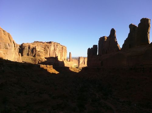
And Utah is like that. I don’t know how many dimensions the state has, but it’s certainly not two, and probably closer to three: the folds in the land; the tumbled cliff faces; the rock fins; the massive outcrops – the way they all loom and dominate forcing your attention. It has the effect of pulling you out of yourself and into the place. You are there now.
After spending the night at Green River State Park I got another early start, headed to Moab, picking up a hitchhiker along the way. And while I didn’t offer a guide to the galaxy, there were a few words about this place and other places as well.
A recent graduate from one of the Eastern universities, he’d been on the road for a while and didn’t seem all that eager to leave it while the weather held. On a recent trip to Zion, I’d finally purchased an annual National Parks pass. I used it to get both of us into Arches, then drove up and out of the canyon of the Colorado, and into the park. We walked a short distance into the rock-way known as Park Avenue.
That was just long enough to allow the first bus load of tourists to find their way there, hissing air brakes announcing their arrival. My dad inherited an old laundry when I was a boy. To this day, I can’t hear that sound without thinking of the steam-presses the workers used in that place. An image of starched shirts came to mind. As the freshly laundered tumbled out of the coach, we made our way out of there.